

Scientists conduct a trawl survey off the coast of New England. (NOAA)
NOAA Fisheries is launching a new tool to better track the location and movement of marine fish in U.S. waters. The Distribution Mapping and Analysis Portal reveals that the ranges of many marine species are shifting, expanding and contracting in response to changing ocean conditions. The interactive website will improve data sharing and collaboration, facilitate decision-making about fishery management and science and increase overall knowledge of species distribution for stock assessments.
The portal displays data from NOAA Fisheries bottom trawl surveys for five regions (Northeast, Southeast, Gulf of Mexico, West Coast and Alaska) and includes a map viewer and graphing capabilities for over 800 marine fish and invertebrate species caught during the surveys. Understanding how species are distributed in space and time, and the factors that drive patterns, are central questions in ecology and important for species conservation and management.
“Our climate and oceans are changing, and these changes are affecting the distribution and abundance of living marine resources in our waters,” said Rick Spinrad, Ph.D., NOAA administrator. “Changes in fish stocks can have significant economic and cultural impacts for communities and businesses across the U.S. The visualization capabilities of this new tool boost our ability to turn the data NOAA collects into robust decision-making resources for the entire fishery management community, helping build a Climate-Ready Nation.” Read the rest at NOAA News..
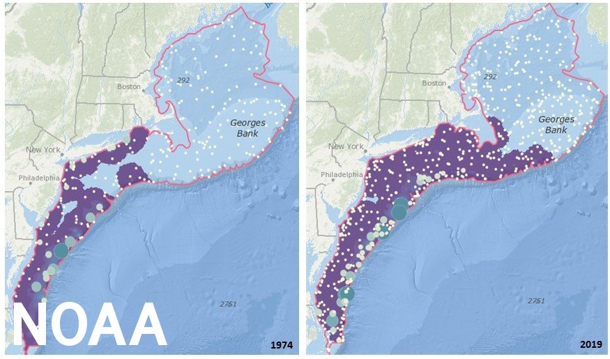
These maps from the Distribution Mapping and Analysis Portal show changes in black sea bass distribution from 1974 to 2019. Black sea bass expanded approximately 140 miles north over this period of time. (NOAA)